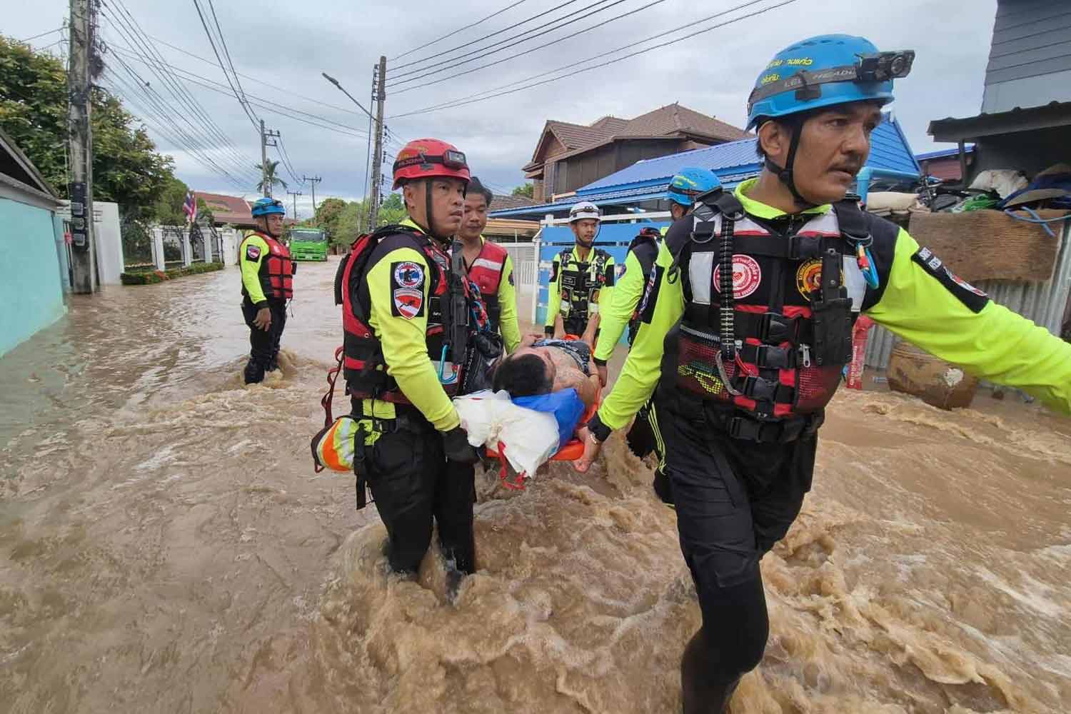
The Yom River surged across several districts in Sukhothai province on Thursday morning as Kajiki’s heavy rainfall continued to swell water levels. Rescue teams evacuated a hospital patient amid the rising floodwaters, underscoring the immediacy of the danger and the urgency of emergency response. By dawn, authorities reported multiple embankment breaches and the closure of key bridges as water pushed into homes and farmland along the river’s path. The river’s advance reflected the broader impact of Kajiki, which has been pummelling northern provinces with persistent downpours, raising concerns about ongoing flood risks in the region.
Hydrological progression and affected districts
The Yom River’s overflow began to manifest in Sukhothai during the early hours of Thursday, with authorities tracing the surge to around 4 a.m. as water breached sections of embankments and began inundating communities along the river’s banks. The governor of the province, Nopparit Sirikosol, confirmed that rainfall from the storm had raised the river’s level in Phrae province, and that the deluge reached Sukhothai by Wednesday night, marking a rapid escalation in flood conditions across multiple districts. The districts most noticeably affected in Sukhothai include Muang, Sawankhalok, Sri Nakhon, and Sri Samrong, reflecting a broad geographical footprint of the inundation within the province.
In the Muang district, the floodwaters breached an embankment and flowed into approximately 300 houses within the Khuha Sawan community in tambon Thanee, illustrating the human-scale impact of the river’s rise. The overflow also affected additional locations along the river’s course: in Wang Hin, a community within tambon Pak Khwae of Muang district saw water breach the embankment, while in Sawankhalok, tambon Khlong Yang was likewise overwhelmed by rising waters. Complicating the flood’s progression, water passed through a sandbag barrier in tambon Yang Sai, again underscoring the challenges of containing a surge that infiltrates multiple protective measures.
The escalating water levels prompted swift safety decisions, with local authorities closing bridges in Muang and Sri Samrong districts to reduce travel risk and prevent accidents on inundated routes. Beyond residential areas, the flood also compromised agricultural lands, inundating farmland in tambon Mae Sin of Sri Satchanalai district and tambon Khlong Yang of Sawankhalok district. These patterns of inundation reveal a complex flood geometry, where embankment breaches, overtopped barriers, and rapid water movement combine to threaten homes, roads, and fields in several communities along the Yom River’s path.
The sequence of events—timing at 4 a.m., embankment breaches, multiple flooded neighborhoods, and targeted barrier failures—paints a detailed picture of how quickly a storm-driven river can shift from high water to active inundation. The interconnected nature of the affected areas, spanning Muang, Sawankhalok, Sri Nakhon, and Sri Samrong, reflects a regional flood event with implications for emergency management, housing protection, and agricultural resilience in Sukhothai.
Impact on communities and infrastructure
The flooding’s immediate consequences extended beyond the loss of land and damage to property. Rescue workers were compelled to act swiftly to safeguard vulnerable residents and critical facilities. Notably, emergency responders evacuated a hospital patient as the Yom River surged, highlighting the urgency of maintaining essential health services in flood conditions and the tricky logistics of moving patients while water levels and road access rapidly deteriorate.
Infrastructure took a direct hit as several bridges were shut down to prevent disaster during the peak flood phase. The closure of key crossings in Muang and Sri Samrong districts disrupted travel and could complicate access to services, supplies, and evacuation routes for residents in affected neighborhoods. These bridge closures, paired with embankment breaches, underscored the vulnerability of transportation networks when river levels rise abruptly.
Homes along the riverbank bore the brunt of the inundation. In Muang’s Khuha Sawan community, roughly 300 houses experienced flooding as water poured over embankments, forcing residents to contend with damp interiors, damaged belongings, and the risk of long-term moisture intrusion. The flood’s reach extended to agricultural zones, with farmland in Mae Sin tambon of Sri Satchanalai district and in Khlong Yang tambon of Sawankhalok district affected. The combination of residential and agricultural losses signals multi-layered economic and social disruption, compelling families to confront displacement, income disruption, and potential long-term crop damage.
The flood’s reach across multiple communities also offered a snapshot of urban-rural spillover effects. In Muang’s Pak Khwae area (Wang Hin), and in Sawankhalok’s Khlong Yang (tambon), water movement through and around barriers created a tapestry of flood pathways that complicated containment and rescue operations. Likewise, water routing through a sandbag barrier in Yang Sai demonstrated both the ingenuity of local flood defenses and their limits under sustained rainfall and rising river levels. Together, these dynamics illustrate how flood events in northern Thailand can simultaneously stress housing, infrastructure, and livelihoods in adjacent communities.
Agricultural loss, already a staple concern in flood episodes, became tangible as fields in Mae Sin and Khlong Yang were inundated. The inundation of farmland threatens crop yields and soil health, with potential knock-on effects for local markets and producer livelihoods if rainfall persists or recurs in the coming days. The incident thus underscores the necessity of rapid assessments, drainage management, and contingency planning to minimize agricultural damage while stabilizing rural economies and food supply chains in flood-prone regions.
Responders and local authorities also faced ongoing pressure to secure additional critical assets and ensure public safety. With river levels fluctuating, the ability to maintain access to emergency services, clinics, and supply routes depended on timely risk assessments and adaptive response strategies. The event highlighted the importance of clear communication with residents about road closures, evacuation advisories, and safety precautions, while also emphasizing the need for robust flood response plans to preserve essential services during peak flood periods.
Emergency response and public safety measures
Government officials and local authorities quickly activated flood response protocols as the Yom River breached its banks in Sukhothai. Governor Nopparit Sirikosol publicly framed the flood as a consequence of Kajiki’s ongoing storm system, stressing that the northern provinces had experienced heavy rains which elevated the river in Phrae and led to flooding conditions arriving in Sukhothai by Wednesday night. The early morning onset—around 4 a.m.—was a critical window for initiating protective actions, including the decision to close bridges and to mobilize rescue and relief teams to affected neighborhoods.
Emergency measures focused on safeguarding residents, preserving critical infrastructure, and maintaining access for emergency services. The sandbag barrier in Yang Sai represented one defensive measure, though its effectiveness in the face of persistent rainfall and rising water levels was tested as floodwaters continued to advance. The closures of bridges in Muang and Sri Samrong districts served as preventive steps to reduce the risk of vehicles becoming stranded or impeded by flooded roadways, while evacuation efforts, such as the hospital patient rescue, demonstrated the priority given to safeguarding vulnerable populations.
In parallel with these immediate actions, local authorities engaged in ongoing risk assessment and communications with residents. The aim was to provide timely information about water levels, road status, and potential evacuation needs. The flooding event also underscored the importance of multi-agency coordination, including civil defense, municipal authorities, and regional disaster response teams, to operate cohesively in the face of rapid riverine flood progression. While the situation remained fluid, the focus on public safety, rapid response, and protective infrastructure measures illustrated a comprehensive approach to flood management in the region.
The broader implication for public safety concerns centers on the ability to maintain essential operations amid flood stress. With hospital facilities requiring continuity of care and with roads and bridges intermittently closed, authorities faced the dual task of protecting life and ensuring medical and logistical access. The response included not only physical barriers and evacuations but also situational awareness, forecasting updates, and community-level alerts to reduce risk and facilitate orderly movement of people away from vulnerable zones.
Environmental and agricultural implications
The flood has direct repercussions for agricultural outputs and rural livelihoods in Sukhothai. The inundation of farmland in Mae Sin and Khlong Yang threatens crop health, soil moisture balance, and future yields. Prolonged waterlogging can compromise root systems, hinder nutrient uptake, and alter soil structure, potentially affecting crop productivity long after the water recedes. Farmers in these tambons may face short-term losses due to damaged or rotted crops, increased weed growth, and delayed planting or harvest schedules. The sudden shift from normal field conditions to water-saturated soils requires careful management and potential adjustments in crop calendars for the growing seasons ahead.
Beyond crop-specific losses, the flood affects soil integrity and field accessibility. Saturated soil can complicate post-flood field operations, slow down planting and cultivation efforts, and increase the risk of erosion when waters recede. Access to farmland for agrarian communities may be restricted by road closures or muddy, unstable ground, limiting timely irrigation, fertilizer application, and nutrient management activities. While the immediate damage is localized to the affected tambons, the cumulative impact on district-level agricultural productivity could influence local markets and income, especially if rainfall persists or recurs in coming weeks.
The weather system Kajiki’s role in sustaining heavy rainfall across northern provinces adds complexity to agricultural recovery planning. Continued precipitation can delay drainage and prolong soils’ saturation, increasing the potential for root diseases and crop stress. Local agricultural authorities and extension services may need to mobilize inspection, drainage assistance, and crop protection guidance to help farmers mitigate risk and plan for longer-term recovery. The incident also underlines the importance of resilient farming practices and flood-aware land use planning to reduce vulnerability to future riverine flooding.
In addition to crop concerns, floodwaters can damage rural infrastructure such as irrigation canals, ditches, and farm access roads. Disrupted irrigation delivery may compound water management challenges for farmers, while eroded or washed-out access roads can hinder the timely movement of inputs and harvested produce. Recovery plans will likely emphasize rapid restoration of essential farm infrastructure, improved drainage, and targeted support for households that rely on farming as their primary livelihood. The convergence of residential, agricultural, and transport impacts underscores the need for integrated recovery efforts that address multiple facets of rural resilience in the wake of flood events.
Weather system Kajiki and northern rainfall patterns
Kajiki’s influence on northern Thailand’s weather has been shaped by a sustained pattern of heavy rainfall that elevates river levels and triggers flood events across provinces. In Sukhothai, the storm’s rainfall contributed to the rapid rise of the Yom River, compounding the cumulative effects of upstream rainfall in Phrae and other affected districts. The retreat and progression of floodwaters hinge on the interplay between ongoing precipitation, river discharge, soil saturation, and the capacity of embankments and barriers to contain the surge. The flood event described in Sukhothai is a clear manifestation of how a single storm system can ripple through multiple municipalities, creating an urgent need for coordinated flood management, timely alerts, and adaptive response strategies.
Meteorological observers emphasize that continued monitoring of Kajiki is essential for predicting further risk. If rainfall persists, the river’s levels may remain elevated or rise again, potentially extending the flood’s footprint to additional communities or reinforcing the need for traffic restrictions and evacuation plans. In this context, the region’s disaster management agencies must maintain readiness to deploy rescue teams, reinforce protective barriers, and coordinate with neighboring provinces that may experience similar flood pressures from Kajiki’s system. The interplay between rainfall intensity, river dynamics, and local protective measures defines the evolving risk landscape for northern Thailand during the Kajiki weather event.
Officials also stress the importance of public awareness and preparedness. Residents in flood-prone zones should stay informed about water levels, bridge status, and safety advisories, while avoiding unnecessary travel through flooded areas. Clear communication about road closures, shelter locations, and evacuation routes remains a cornerstone of effective flood response. The ongoing storm system’s influence on rainfall distribution and river behavior requires a proactive stance from local authorities, communities, and responders to reduce harm and facilitate rapid, organized responses as conditions change.
Infrastructure resilience and future preparedness
The Sukhothai flood episode underscores the critical role of infrastructure resilience in mitigating riverine flood damage. Embankments, bridges, and flood barriers all contribute to a protective shield against rising waters, but their limitations become apparent when confronted with rapid surges and persistent rainfall. The 4 a.m. onset of overflow and the subsequent breaches highlight the need for regular maintenance, proactive reinforcement, and contingency planning to prevent or reduce devastating water ingress into homes and farms. Ensuring the reliability of protective structures is essential not only for immediate safety but also for sustaining agricultural productivity and rural livelihoods in flood-prone regions.
Investments in flood management may include improved spillways, upgraded embankment materials, enhanced riverine drainage capacity, and the strategic placement of temporary barriers that can be deployed quickly in response to rising water. The ability to coordinate rapid evacuations, protect critical facilities like hospitals, and maintain accessible transport routes depends on robust planning and inter-agency cooperation. The incident in Sukhothai suggests that local authorities, in partnership with regional disaster management agencies, should prioritize strengthening protective barriers, expanding early warning systems, and refining emergency response protocols to respond effectively to future Kajiki-driven flood events.
Long-term resilience also requires community engagement and education. Residents living near the Yom River can benefit from flood preparedness programs, household flood-readiness plans, and community drills that simulate rapid evacuation and sheltering procedures. Data-driven risk assessments can inform land-use planning, zoning decisions, and infrastructure investments to reduce vulnerability in high-risk zones. As climate variability continues to influence rainfall patterns, a proactive approach to flood risk mitigation—integrating infrastructure upgrades, early warning enhancements, and community collaboration—will be critical to safeguarding lives, homes, and livelihoods in northern Thailand.
The current episode also emphasizes the importance of inter-provincial coordination. Since Kajiki’s effects span multiple provinces, disaster response and resource sharing across provincial boundaries can augment local capabilities. Joint exercises, shared inventory of flood-control materials, and coordinated deployment of emergency personnel can improve efficiency and effectiveness when floods threaten large areas or cross-border river basins. Strengthening such collaboration can help ensure that when the Yom River overflows again, the region is better prepared to respond swiftly and cohesively, minimizing damage and facilitating faster recovery for affected communities.
Practical guidance for residents and farmers
Residents in flood-prone areas should remain vigilant for updates from local authorities, heed bridge closures, and avoid trying to navigate flooded roads. Evacuation plans should be reviewed and practiced, and emergency kits with essential supplies should be kept ready to deploy if conditions worsen. For households adjacent to the Yom River, securing valuables, elevating important documents, and preparing for potential temporary displacement can help reduce losses and stress during flood events.
Farmers facing inundated fields should work with agricultural extension services to assess crop damage, evaluate soil health, and determine best practices for post-flood recovery. Timely drainage assessment and soil management strategies can help mitigate long-term impacts on yields and farm productivity. In addition, understanding crop alternatives or adjustments to planting schedules can enable producers to minimize revenue disruption if future rainfall events occur within the growing season.
Public safety messaging should emphasize the importance of crossing flooded areas only when authorities declare it safe and authorized. People should avoid wading through floodwaters, as moving water can conceal hazards such as open manholes, sharp debris, or untreated drains. Community shelters can provide safe havens for those displaced by flooding, and residents should be encouraged to seek shelter and support through official channels rather than venturing into dangerous areas.
The Yom River’s recent overflow reveals the complexity of flood dynamics in northern Thailand, where heavy rainfall from Kajiki interacts with riverine systems to create outsized flood risks. Effective management requires a blend of infrastructure resilience, proactive emergency response, clear public communication, and community readiness. By combining these elements, the region can better withstand future flood events, protect vulnerable populations, and sustain agricultural livelihoods in the face of changing weather patterns.
Conclusion
The Thursday morning overflow of the Yom River in Sukhothai province, driven by the Kajiki storm’s sustained rainfall, resulted in embankment breaches, bridge closures, and widespread inundation across Muang, Sawankhalok, Sri Nakhon, and Sri Samrong districts. The flood directly affected around 300 homes in the Khuha Sawan community, with additional inundation of farms in Mae Sin and Khlong Yang. Rescue operations, including the evacuation of a hospital patient, underscored the immediacy and gravity of the situation. Authorities have emphasized the continuing risk posed by Kajiki, as heavy rains continue to influence northern provinces and drive river levels higher.
In response, local officials closed affected bridges, reinforced protection measures such as sandbag barriers, and implemented evacuation and safety protocols to protect residents and critical facilities. The event highlights the importance of cohesive flood management strategies, including infrastructure resilience, early warning systems, and coordinated disaster response across districts and provinces. It also underscores the need for ongoing support for farmers and rural communities whose livelihoods depend on stable riverine environments and reliable agricultural inputs.
As Kajiki’s impact persists, communities in Sukhothai and neighboring regions must stay vigilant, adhere to safety advisories, and participate in preparedness efforts designed to minimize risk and facilitate rapid recovery. The lessons from this flood event—about embankment integrity, barrier effectiveness, and emergency response agility—should inform future planning and investment to strengthen resilience against recurring river-based hazards.